Rabu, 31 Maret 2010

[sipongi] Digest Number 1881[2 Attachments]

Messages In This Digest (1 Message)

Message

1.

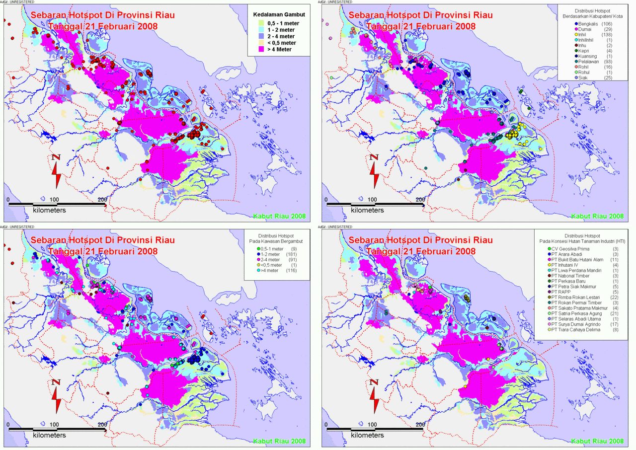
Informasi Titik Panas 31 Maret 2010

Posted by: "pongi" pongi@cbn.net.id

Wed Mar 31, 2010 2:34 am (PDT)

[Attachment(s) from pongi included below]

Salam Pongi,

Kami informasikan hasil pantauan titik panas tanggal 31 Maret 2010.

Demikian info kami.

Untuk informasi hotspot dari Satelit MODIS,

Silahkan kunjungi website INDOFIRE di http://indofire.dephut.go.id

Operator.

----------------------------------------------------------

Stasiun Bumi Satelit NOAA

Direktorat Pengendalian Kebakaran Hutan,

Direktorat Jenderal Perlindungan Hutan dan Konservasi Alam,

Departemen Kehutanan.

Gedung Manggala Wanabakti Blok VII Lt 13.

JAKARTA.

_____

mar3101.jpg

Attachment(s) from pongi

2 of 2 File(s)

Recent Activity
Visit Your Group
Yahoo! Groups

Mental Health Zone

Bi-polar disorder

Find support

Y! Groups blog

the best source

for the latest

scoop on Groups.

Group Charity

i-SAFE

Keep your kids

safer online

Need to Reply?

Click one of the "Reply" links to respond to a specific message in the Daily Digest.

Create New Topic | Visit Your Group on the Web
MARKETPLACE

Do More for Dogs Group. Connect with other dog owners who do more.


Welcome to Mom Connection! Share stories, news and more with moms like you.


Hobbies & Activities Zone: Find others who share your passions! Explore new interests.

FIRMS: Daily Fire Alert

FIRMS Global Fire Alerts - UN-FAO/UMD/NASA 
View Your Subscriptions  • FIRMS Home  • FAQ


Your Area of Interest (Coordinates) : 99.19, -1.79, 104.7, 3.12

Fires detected over the past 24 hours in your area-of-interest : 1

(NOTE: Cloud cover might obscure active fire detections. The fire points will be listed only when the total number of active fires detected is less than or equal to 50)

This email was generated on 2010-03-31 , 08:57:18 UTC by FIRMS in partnership with the United Nations Food and Agriculture Organization (UN FAO) and MODIS Rapid Response. FIRMS will be transitioned to UN FAO under the name "Global Fire Information Management System (GFIMS)". GFIMS will take over from the FIRMS system at a later date.
LATITUDE LONGITUDE CONFIDENCE DATE TIME SATELLITE
2.76399.726632010-03-30 06:40A


If you have any questions or comments, go to the Frequently Asked Questions (http://maps.geog.umd.edu/firms/faq.htm) or contact the FIRMS Team. To query the full active fire database for your area, go to FIRMS Home (http://maps.geog.umd.edu/). Please read the disclaimer below.


Disclaimer: The data in this email are made available by the Food and Agriculture Organization of the United Nations (FAO), in partnership with the University of Maryland and NASA MODIS Rapid Response. The data has not been modified and is as received from MODIS Rapid Response. Data, databases and other information made available through the Fire Information for Resource Management System (FIRMS) are provided "as is" and users bear all responsibility and liability for their use of data, and for any loss of business or profits, or for any indirect, incidental or consequential damages arising out of any use of, or inability to use, the data, even if FAO or the University of Maryland were previously advised of the possibility of such damages, or for any other claim by you or any other person. FAO or the University of Maryland make no representations or warranties of any kind, express or implied, including implied warranties of fitness for a particular purpose or merchantability, or with respect to the accuracy of or the absence or the presence or defects or errors in data, databases of other information. The designations employed in the data do not imply the expression of any opinion whatsoever on the part of FAO concerning the legal or development status of any country, territory, city or area or of its authorities, or concerning the delimitation of its frontiers or boundaries. For more information please go to http://maps.geog.umd.edu/firms/disclaimer.htm

Selasa, 30 Maret 2010

[sipongi] Digest Number 1880[2 Attachments]

Messages In This Digest (1 Message)

Message

1.

Informasi Titik Panas 30 Maret 2010

Posted by: "pongi" pongi@cbn.net.id

Tue Mar 30, 2010 2:19 am (PDT)

[Attachment(s) from pongi included below]

Salam Pongi,

Kami informasikan hasil pantauan titik panas tanggal 30 Maret 2010.

Demikian info kami.

Untuk informasi hotspot dari Satelit MODIS,

Silahkan kunjungi website INDOFIRE di http://indofire.dephut.go.id

Operator.

----------------------------------------------------------

Stasiun Bumi Satelit NOAA

Direktorat Pengendalian Kebakaran Hutan,

Direktorat Jenderal Perlindungan Hutan dan Konservasi Alam,

Departemen Kehutanan.

Gedung Manggala Wanabakti Blok VII Lt 13.

JAKARTA.

_____

mar3001.jpg

Attachment(s) from pongi

2 of 2 File(s)

Recent Activity
Visit Your Group
Y! Groups blog

The place to go

to stay informed

on Groups news!

Yahoo! Groups

Mental Health Zone

Find support for

Mental illnesses

Cat Fanatics

on Yahoo! Groups

Find people who are

crazy about cats.

Need to Reply?

Click one of the "Reply" links to respond to a specific message in the Daily Digest.

Create New Topic | Visit Your Group on the Web

FIRMS: Daily Fire Alert

FIRMS Global Fire Alerts - UN-FAO/UMD/NASA 
View Your Subscriptions  • FIRMS Home  • FAQ


Your Area of Interest (Coordinates) : 99.19, -1.79, 104.7, 3.12

Fires detected over the past 24 hours in your area-of-interest : 1

(NOTE: Cloud cover might obscure active fire detections. The fire points will be listed only when the total number of active fires detected is less than or equal to 50)

This email was generated on 2010-03-30 , 08:56:55 UTC by FIRMS in partnership with the United Nations Food and Agriculture Organization (UN FAO) and MODIS Rapid Response. FIRMS will be transitioned to UN FAO under the name "Global Fire Information Management System (GFIMS)". GFIMS will take over from the FIRMS system at a later date.
LATITUDE LONGITUDE CONFIDENCE DATE TIME SATELLITE
0.505103.369422010-03-29 15:15T


If you have any questions or comments, go to the Frequently Asked Questions (http://maps.geog.umd.edu/firms/faq.htm) or contact the FIRMS Team. To query the full active fire database for your area, go to FIRMS Home (http://maps.geog.umd.edu/). Please read the disclaimer below.


Disclaimer: The data in this email are made available by the Food and Agriculture Organization of the United Nations (FAO), in partnership with the University of Maryland and NASA MODIS Rapid Response. The data has not been modified and is as received from MODIS Rapid Response. Data, databases and other information made available through the Fire Information for Resource Management System (FIRMS) are provided "as is" and users bear all responsibility and liability for their use of data, and for any loss of business or profits, or for any indirect, incidental or consequential damages arising out of any use of, or inability to use, the data, even if FAO or the University of Maryland were previously advised of the possibility of such damages, or for any other claim by you or any other person. FAO or the University of Maryland make no representations or warranties of any kind, express or implied, including implied warranties of fitness for a particular purpose or merchantability, or with respect to the accuracy of or the absence or the presence or defects or errors in data, databases of other information. The designations employed in the data do not imply the expression of any opinion whatsoever on the part of FAO concerning the legal or development status of any country, territory, city or area or of its authorities, or concerning the delimitation of its frontiers or boundaries. For more information please go to http://maps.geog.umd.edu/firms/disclaimer.htm

Senin, 29 Maret 2010

[sipongi] Digest Number 1879[8 Attachments]

Messages In This Digest (4 Messages)

Messages

1.

Informasi Titik Panas 27 Maret 2010

Posted by: "pongi" pongi@cbn.net.id

Sun Mar 28, 2010 6:48 pm (PDT)

[Attachment(s) from pongi included below]


Salam Pongi,

Kami informasikan hasil pantauan titik panas tanggal 27 Maret 2010.

Demikian info kami.

Untuk informasi hotspot dari Satelit MODIS,

Silahkan kunjungi website INDOFIRE di http://indofire.dephut.go.id

Operator.

----------------------------------------------------------

Stasiun Bumi Satelit NOAA

Direktorat Pengendalian Kebakaran Hutan,

Direktorat Jenderal Perlindungan Hutan dan Konservasi Alam,

Departemen Kehutanan.

Gedung Manggala Wanabakti Blok VII Lt 13.

JAKARTA.

_____

mar2701.jpg

Attachment(s) from pongi

2 of 2 File(s)

2a.

Informasi Titik Panas 28 Maret 2010

Posted by: "pongi" pongi@cbn.net.id

Sun Mar 28, 2010 7:13 pm (PDT)

[Attachment(s) from pongi included below]

Salam Pongi,

Kami informasikan hasil pantauan titik panas tanggal 28 Maret 2010.

Demikian info kami.

Untuk informasi hotspot dari Satelit MODIS,

Silahkan kunjungi website INDOFIRE di http://indofire.dephut.go.id

Operator.

----------------------------------------------------------

Stasiun Bumi Satelit NOAA

Direktorat Pengendalian Kebakaran Hutan,

Direktorat Jenderal Perlindungan Hutan dan Konservasi Alam,

Departemen Kehutanan.

Gedung Manggala Wanabakti Blok VII Lt 13.

JAKARTA.

_____

mar2801.jpg

Attachment(s) from pongi

2 of 2 File(s)

2b.

Informasi Titik Panas 28 Maret 2010

Posted by: "pongi" pongi@cbn.net.id

Sun Mar 28, 2010 8:13 pm (PDT)

[Attachment(s) from pongi included below]

Salam Pongi,

Kami informasikan hasil pantauan titik panas tanggal 28 Maret 2010.

Demikian info kami.

Untuk informasi hotspot dari Satelit MODIS,

Silahkan kunjungi website INDOFIRE di http://indofire.dephut.go.id

Operator.

----------------------------------------------------------

Stasiun Bumi Satelit NOAA

Direktorat Pengendalian Kebakaran Hutan,

Direktorat Jenderal Perlindungan Hutan dan Konservasi Alam,

Departemen Kehutanan.

Gedung Manggala Wanabakti Blok VII Lt 13.

JAKARTA.

_____

mar2801.jpg

Attachment(s) from pongi

2 of 2 File(s)

3.

Informasi Titik Panas 29 Maret 2010

Posted by: "pongi" pongi@cbn.net.id

Mon Mar 29, 2010 2:11 am (PDT)

[Attachment(s) from pongi included below]

Salam Pongi,

Kami informasikan hasil pantauan titik panas tanggal 29 Maret 2010.

Demikian info kami.

Untuk informasi hotspot dari Satelit MODIS,

Silahkan kunjungi website INDOFIRE di http://indofire.dephut.go.id

Operator.

----------------------------------------------------------

Stasiun Bumi Satelit NOAA

Direktorat Pengendalian Kebakaran Hutan,

Direktorat Jenderal Perlindungan Hutan dan Konservasi Alam,

Departemen Kehutanan.

Gedung Manggala Wanabakti Blok VII Lt 13.

JAKARTA.

_____

mar2901.jpg

Attachment(s) from pongi

2 of 2 File(s)

Recent Activity
Visit Your Group
Yahoo! Groups

Mental Health Zone

Learn about issues

Find support

Group Charity

i-SAFE

Keep your kids

safer online

Y! Groups blog

The place to go

to stay informed

on Groups news!

Need to Reply?

Click one of the "Reply" links to respond to a specific message in the Daily Digest.

Create New Topic | Visit Your Group on the Web

FIRMS: Daily Fire Alert

FIRMS Global Fire Alerts - UN-FAO/UMD/NASA 
View Your Subscriptions  • FIRMS Home  • FAQ


Your Area of Interest (Coordinates) : 99.19, -1.79, 104.7, 3.12

Fires detected over the past 24 hours in your area-of-interest : 28

(NOTE: Cloud cover might obscure active fire detections. The fire points will be listed only when the total number of active fires detected is less than or equal to 50)

This email was generated on 2010-03-29 , 09:01:06 UTC by FIRMS in partnership with the United Nations Food and Agriculture Organization (UN FAO) and MODIS Rapid Response. FIRMS will be transitioned to UN FAO under the name "Global Fire Information Management System (GFIMS)". GFIMS will take over from the FIRMS system at a later date.
LATITUDE LONGITUDE CONFIDENCE DATE TIME SATELLITE
2.911103.2631002010-03-28 03:50T
2.9103.262772010-03-28 03:50T
2.372103.567502010-03-28 03:50T
1.858104.071652010-03-28 03:50T
2.163100.809452010-03-28 03:50T
1.39101.049562010-03-28 03:50T
0.275100.809472010-03-28 03:50T
0.005101.694652010-03-28 03:50T
-0.127101.962452010-03-28 03:50T
-0.373102.651532010-03-28 06:50A
-0.553101.323382010-03-28 06:50A
-0.208102.383462010-03-28 06:50A
-0.136102.311922010-03-28 06:50A
-0.138102.302422010-03-28 06:50A
-0.127102.31712010-03-28 06:50A
-0.295101.068622010-03-28 06:50A
0.139101.139452010-03-28 06:50A
0.228100.736592010-03-28 06:50A
0.25599.96512010-03-28 06:50A
1.055102.996902010-03-28 06:50A
1.34102.469762010-03-28 06:50A
1.501101.856412010-03-28 06:50A
1.836101.683352010-03-28 06:50A
1.845101.682612010-03-28 06:50A
1.948101.563512010-03-28 06:50A
1.947101.554732010-03-28 06:50A
2.075101.229302010-03-28 06:50A
3.088103.439612010-03-28 06:50A


If you have any questions or comments, go to the Frequently Asked Questions (http://maps.geog.umd.edu/firms/faq.htm) or contact the FIRMS Team. To query the full active fire database for your area, go to FIRMS Home (http://maps.geog.umd.edu/). Please read the disclaimer below.


Disclaimer: The data in this email are made available by the Food and Agriculture Organization of the United Nations (FAO), in partnership with the University of Maryland and NASA MODIS Rapid Response. The data has not been modified and is as received from MODIS Rapid Response. Data, databases and other information made available through the Fire Information for Resource Management System (FIRMS) are provided "as is" and users bear all responsibility and liability for their use of data, and for any loss of business or profits, or for any indirect, incidental or consequential damages arising out of any use of, or inability to use, the data, even if FAO or the University of Maryland were previously advised of the possibility of such damages, or for any other claim by you or any other person. FAO or the University of Maryland make no representations or warranties of any kind, express or implied, including implied warranties of fitness for a particular purpose or merchantability, or with respect to the accuracy of or the absence or the presence or defects or errors in data, databases of other information. The designations employed in the data do not imply the expression of any opinion whatsoever on the part of FAO concerning the legal or development status of any country, territory, city or area or of its authorities, or concerning the delimitation of its frontiers or boundaries. For more information please go to http://maps.geog.umd.edu/firms/disclaimer.htm

Minggu, 28 Maret 2010

FIRMS: Daily Fire Alert

FIRMS Global Fire Alerts - UN-FAO/UMD/NASA 
View Your Subscriptions  • FIRMS Home  • FAQ


Your Area of Interest (Coordinates) : 99.19, -1.79, 104.7, 3.12

Fires detected over the past 24 hours in your area-of-interest : 16

(NOTE: Cloud cover might obscure active fire detections. The fire points will be listed only when the total number of active fires detected is less than or equal to 50)

This email was generated on 2010-03-28 , 08:58:20 UTC by FIRMS in partnership with the United Nations Food and Agriculture Organization (UN FAO) and MODIS Rapid Response. FIRMS will be transitioned to UN FAO under the name "Global Fire Information Management System (GFIMS)". GFIMS will take over from the FIRMS system at a later date.
LATITUDE LONGITUDE CONFIDENCE DATE TIME SATELLITE
1.049102.9641002010-03-27 15:30T
2.21103.417382010-03-27 15:30T
2.369103.563402010-03-27 15:30T
0.136102.742202010-03-27 06:05A
2.607103.468392010-03-27 06:05A
2.605103.463572010-03-27 06:05A
2.712103.526832010-03-27 18:25A
2.911103.2631002010-03-28 03:50T
2.9103.262772010-03-28 03:50T
2.372103.567502010-03-28 03:50T
1.858104.071652010-03-28 03:50T
2.163100.809452010-03-28 03:50T
1.39101.049562010-03-28 03:50T
0.275100.809472010-03-28 03:50T
0.005101.694652010-03-28 03:50T
-0.127101.962452010-03-28 03:50T


If you have any questions or comments, go to the Frequently Asked Questions (http://maps.geog.umd.edu/firms/faq.htm) or contact the FIRMS Team. To query the full active fire database for your area, go to FIRMS Home (http://maps.geog.umd.edu/). Please read the disclaimer below.


Disclaimer: The data in this email are made available by the Food and Agriculture Organization of the United Nations (FAO), in partnership with the University of Maryland and NASA MODIS Rapid Response. The data has not been modified and is as received from MODIS Rapid Response. Data, databases and other information made available through the Fire Information for Resource Management System (FIRMS) are provided "as is" and users bear all responsibility and liability for their use of data, and for any loss of business or profits, or for any indirect, incidental or consequential damages arising out of any use of, or inability to use, the data, even if FAO or the University of Maryland were previously advised of the possibility of such damages, or for any other claim by you or any other person. FAO or the University of Maryland make no representations or warranties of any kind, express or implied, including implied warranties of fitness for a particular purpose or merchantability, or with respect to the accuracy of or the absence or the presence or defects or errors in data, databases of other information. The designations employed in the data do not imply the expression of any opinion whatsoever on the part of FAO concerning the legal or development status of any country, territory, city or area or of its authorities, or concerning the delimitation of its frontiers or boundaries. For more information please go to http://maps.geog.umd.edu/firms/disclaimer.htm
Photobucket