3.762,108.319,313,1.2,1.1,2019-04-23,1810,Aqua,77,6.0NRT,272.2,14
3.763,108.309,313.5,1.2,1.1,2019-04-23,1810,Aqua,37,6.0NRT,271.1,14
3.768,108.277,316.2,1.2,1.1,2019-04-23,1810,Aqua,51,6.0NRT,269,16.8
3.769,108.267,357.2,1.2,1.1,2019-04-23,1810,Aqua,100,6.0NRT,271.2,100.4
3.778,108.279,330.4,1.2,1.1,2019-04-23,1810,Aqua,100,6.0NRT,270.4,35.3
3.787,108.28,322.7,1.2,1.1,2019-04-23,1810,Aqua,86,6.0NRT,269.7,23.8
3.795,108.292,329.4,1.2,1.1,2019-04-23,1810,Aqua,97,6.0NRT,269.6,32.5
3.797,108.281,342,1.2,1.1,2019-04-23,1810,Aqua,100,6.0NRT,270.5,57.7
3.294,103.404,310,1.4,1.2,2019-04-23,1520,Terra,61,6.0NRT,286.5,12.3
3.245,103.043,311.6,1.5,1.2,2019-04-23,1520,Terra,76,6.0NRT,282.7,16.9
3.134,103.21,308,1.4,1.2,2019-04-23,1520,Terra,58,6.0NRT,280.3,14.8
3.795,108.252,319.6,2.2,1.4,2019-04-23,0555,Aqua,23,6.0NRT,289.8,34
3.798,108.272,354.5,2.2,1.4,2019-04-23,0555,Aqua,97,6.0NRT,290.6,205.1
3.801,108.291,317.8,2.2,1.4,2019-04-23,0555,Aqua,30,6.0NRT,289.9,22.9
3.782,108.254,335.5,2.2,1.4,2019-04-23,0555,Aqua,0,6.0NRT,290.3,88.1
3.785,108.274,421.4,2.2,1.4,2019-04-23,0555,Aqua,94,6.0NRT,295.4,1245.6
3.788,108.293,363.4,2.2,1.4,2019-04-23,0555,Aqua,100,6.0NRT,292,266.3
3.791,108.313,331.7,2.2,1.4,2019-04-23,0555,Aqua,59,6.0NRT,291.2,67
3.772,108.276,400.9,2.2,1.4,2019-04-23,0555,Aqua,87,6.0NRT,291.8,779.7
3.759,108.278,323.2,2.2,1.4,2019-04-23,0555,Aqua,17,6.0NRT,289.9,41.7
3.762,108.297,356.7,2.2,1.4,2019-04-23,0555,Aqua,98,6.0NRT,292.4,218.7
3.765,108.317,391.9,2.2,1.4,2019-04-23,0555,Aqua,87,6.0NRT,296,616.9
3.749,108.299,359,2.2,1.4,2019-04-23,0555,Aqua,94,6.0NRT,291.5,239.3
3.752,108.318,379.9,2.2,1.4,2019-04-23,0555,Aqua,0,6.0NRT,292.5,454
3.773,108.283,375,2.2,1.4,2019-04-23,0555,Aqua,75,6.0NRT,290.9,396
3.776,108.302,333.6,2.2,1.4,2019-04-23,0555,Aqua,81,6.0NRT,291.7,80.6
3.76,108.285,330.3,2.2,1.4,2019-04-23,0555,Aqua,52,6.0NRT,290.7,69.4
3.763,108.304,374.8,2.2,1.4,2019-04-23,0555,Aqua,87,6.0NRT,293.4,395.1
3.75,108.306,390.5,2.2,1.4,2019-04-23,0555,Aqua,100,6.0NRT,292.9,0
3.753,108.325,371,2.2,1.4,2019-04-23,0555,Aqua,100,6.0NRT,291.4,350.4
3.753,108.31,342.3,1.9,1.4,2019-04-23,0255,Terra,0,6.0NRT,292.6,101.5
3.765,108.312,382.5,1.9,1.4,2019-04-23,0255,Terra,71,6.0NRT,297.3,406.2
3.777,108.313,333.1,1.9,1.4,2019-04-23,0255,Terra,66,6.0NRT,292.7,56.8
| NASA FIRMS: Fire Email Alert 33 fires/hotspots detected in your area-of-interest in the past 24 hours | |||||
| (lat:-3.23, lon:94.43, lat: 4.24, lon:109.37)
View map image on NASA FIRMS server NOTE: Cloud cover might obscure active fire detections. This email was generated on 2019-04-24 09:51:38 UTC NASA FIRMS Data Source: MODIS Collection 6 NRT | |||||
| |||||
|
|


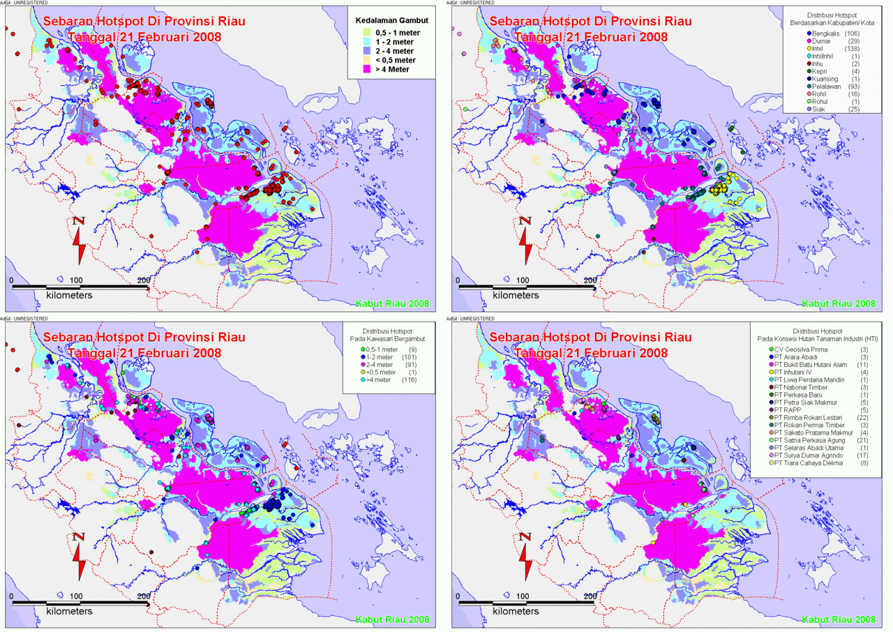
![[Hotspot+February+Kumulatif.gif]](https://blogger.googleusercontent.com/img/b/R29vZ2xl/AVvXsEiE7noWgaqECLYtKeyNcu29bQGBKqd60aooasO9ZTXF-Ct9aIChNGSyKfrGxdhiswsZRrQLoypOsXpVL6BtfYpk6gDW6XJhL3-MBcHatIAHhqTebu951v8GhuJvXCgtyBqlXAXuR3vnd7n6/s1600/Hotspot+February+Kumulatif.gif)


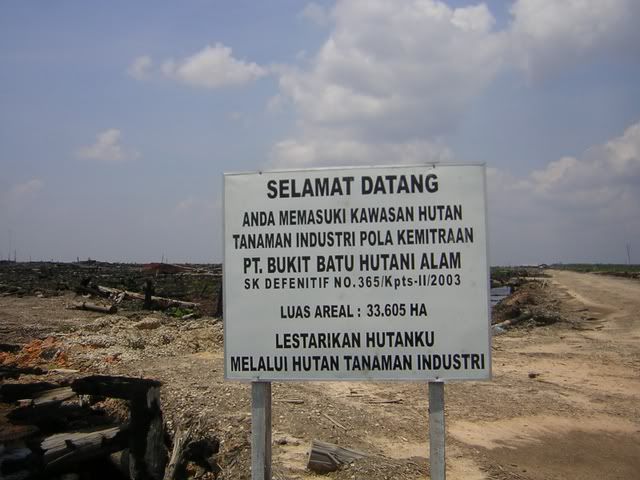
![[hotspot+9-22+mei+08.gif]](https://blogger.googleusercontent.com/img/b/R29vZ2xl/AVvXsEimOA7wvCSbPdM0vgcMWqQKECcTT3zuTOWy75Pox0ANE2UEBHsgTQ-WgltyNRaquBjvQ_DTuv1JJbqL19EtgXrNyteRwPLMmNCVb96wX5hyphenhyphengOSv31gpU4Bh4_vfz6cNdVc6ta8IEMick9Ce/s1600/hotspot+9-22+mei+08.gif)
Tidak ada komentar:
Posting Komentar