3.783,108.275,322.8,4.1,1.9,2019-04-15,1900,Aqua,100,6.0NRT,290.9,153.5
3.8,108.278,313.6,4.1,1.9,2019-04-15,1900,Aqua,82,6.0NRT,291.1,91
3.788,108.28,324.9,4.1,1.9,2019-04-15,1900,Aqua,100,6.0NRT,291,172.7
3.715,108.285,315.7,2.1,1.4,2019-04-15,0640,Aqua,0,6.0NRT,296.4,16.8
1.905,100.312,316.3,1.2,1.1,2019-04-15,0640,Aqua,60,6.0NRT,297.6,9.7
1.227,99.849,316.7,1.2,1.1,2019-04-15,0640,Aqua,64,6.0NRT,296.3,12.3
0.91,101.785,315.9,1,1,2019-04-15,0640,Aqua,22,6.0NRT,293.9,6.8
0.86,102.087,321.2,1,1,2019-04-15,0640,Aqua,55,6.0NRT,300.2,9.6
0.855,102.245,316,1,1,2019-04-15,0640,Aqua,20,6.0NRT,294.7,7.2
0.726,102.823,315.4,1,1,2019-04-15,0640,Aqua,42,6.0NRT,295.1,7.8
0.595,102.036,318.8,1,1,2019-04-15,0640,Aqua,38,6.0NRT,300.2,8.4
0.653,102.821,315.1,1,1,2019-04-15,0640,Aqua,58,6.0NRT,295.9,8.7
-0.196,101.838,324.2,1,1,2019-04-15,0640,Aqua,75,6.0NRT,295.9,15.7
-0.875,101.662,315.4,1.1,1,2019-04-15,0640,Aqua,46,6.0NRT,296.4,8
-0.043,109.877,317.1,2.4,1.5,2019-04-15,0640,Aqua,32,6.0NRT,294.9,26.2
-1.23,101.815,313.9,1.1,1,2019-04-15,0640,Aqua,64,6.0NRT,294.4,5.9
-1.475,101.658,313.3,1.1,1,2019-04-15,0640,Aqua,62,6.0NRT,296.4,6.1
-0.497,109.734,317.4,2.3,1.5,2019-04-15,0640,Aqua,40,6.0NRT,294.9,27.1
-0.492,109.775,319.7,2.3,1.5,2019-04-15,0640,Aqua,37,6.0NRT,294.4,32.6
-3.475,103.495,319.1,1,1,2019-04-15,0640,Aqua,69,6.0NRT,301.1,10.1
-3.792,103.532,323.1,1,1,2019-04-15,0640,Aqua,31,6.0NRT,304.3,11.1
-3.787,103.692,319.9,1,1,2019-04-15,0640,Aqua,31,6.0NRT,302.1,9.4
1.988,117.343,310.2,4.3,1.9,2019-04-15,0505,Aqua,26,6.0NRT,290.1,45
1.536,124.906,317.4,1.2,1.1,2019-04-15,0505,Aqua,41,6.0NRT,299.3,9.5
1.04,122.124,314.2,1.9,1.3,2019-04-15,0505,Aqua,8,6.0NRT,296.6,16.1
1.495,127.632,349.6,1,1,2019-04-15,0505,Aqua,95,6.0NRT,294.8,56.7
1.486,127.633,344.1,1,1,2019-04-15,0505,Aqua,92,6.0NRT,296.1,45.8
1.316,128.181,317.6,1,1,2019-04-15,0505,Aqua,67,6.0NRT,295.3,8.1
-2.439,133.137,316.2,1.7,1.3,2019-04-15,0500,Aqua,0,6.0NRT,288.6,16.5
-5.158,119.427,314.5,3.8,1.8,2019-04-15,0500,Aqua,0,6.0NRT,291.9,57.1
-3.786,103.538,318.1,1.4,1.2,2019-04-15,0345,Terra,31,6.0NRT,299.1,11.7
-1.346,103.749,317.3,1.3,1.1,2019-04-15,0345,Terra,63,6.0NRT,296,15.1
-1.344,103.737,314.2,1.3,1.1,2019-04-15,0345,Terra,21,6.0NRT,295.2,11.3
0.037,102.419,316.7,1.1,1,2019-04-15,0345,Terra,42,6.0NRT,297.8,8.6
0.077,102.406,315.5,1.1,1,2019-04-15,0345,Terra,66,6.0NRT,296.2,9.2
0.867,102.8,312.7,1.1,1,2019-04-15,0345,Terra,58,6.0NRT,293.7,7.6
1.029,101.695,308.8,1,1,2019-04-15,0345,Terra,0,6.0NRT,287.5,5.1
1.477,101.781,307.3,1,1,2019-04-15,0345,Terra,18,6.0NRT,283.8,3.5
3.732,108.293,317.2,2.3,1.5,2019-04-15,0345,Terra,0,6.0NRT,296,26.6
| NASA FIRMS: Fire Email Alert 39 fires/hotspots detected in your area-of-interest in the past 24 hours | |||||
| (Country: Indonesia)
View map image on NASA FIRMS server NOTE: Cloud cover might obscure active fire detections. This email was generated on 2019-04-16 09:31:48 UTC NASA FIRMS Data Source: MODIS Collection 6 NRT | |||||
| |||||
|
|


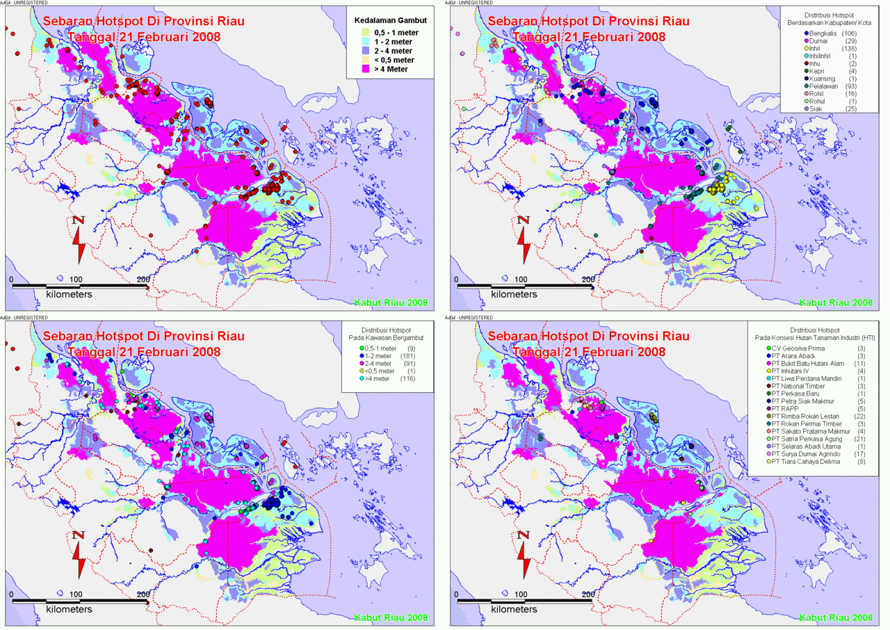
![[Hotspot+February+Kumulatif.gif]](https://blogger.googleusercontent.com/img/b/R29vZ2xl/AVvXsEiE7noWgaqECLYtKeyNcu29bQGBKqd60aooasO9ZTXF-Ct9aIChNGSyKfrGxdhiswsZRrQLoypOsXpVL6BtfYpk6gDW6XJhL3-MBcHatIAHhqTebu951v8GhuJvXCgtyBqlXAXuR3vnd7n6/s1600/Hotspot+February+Kumulatif.gif)


![[hotspot+9-22+mei+08.gif]](https://blogger.googleusercontent.com/img/b/R29vZ2xl/AVvXsEimOA7wvCSbPdM0vgcMWqQKECcTT3zuTOWy75Pox0ANE2UEBHsgTQ-WgltyNRaquBjvQ_DTuv1JJbqL19EtgXrNyteRwPLMmNCVb96wX5hyphenhyphengOSv31gpU4Bh4_vfz6cNdVc6ta8IEMick9Ce/s1600/hotspot+9-22+mei+08.gif)
Tidak ada komentar:
Posting Komentar